March 14, 2014
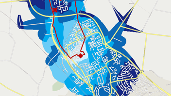
The Spread of Peterborough gyms and most likely where you'll find us in the coming months.
Importantly, the Atlas Mapping team need to know where their local gyms are in order to start training for their Tough Mudder event in the summer (find out more here). So what we’ve done is plot the locations of the gyms in Peterborough and our home locations. Then we’ve created a basic star diagram showing the gyms we attend and shaded those gyms to match our colours. Furthermore, drive-time zones of 5, 10, 15 and 20 minutes have been applied to show the distance and time we are willing to travel in order to train.
As you can see, Stuart (the orange marker) travels within a 5 minute drive time to his local gym. Whereas, Ash (the red marker) travels within 10 minutes to his local gym and over 15 minutes to another gym which is located near the Atlas Mapping office and therefore ideal for before work training. Luckily for the team, there is no shortage of places and gyms to train as proven by the data in the image, so there can be no excuses for not being more than ready for the event in July.
Whilst we are doing our best to get ourselves ready for the event if you would like to support us and donate towards a great cause please follow the link here, it’s greatly appreciated.