March 17, 2026
If you have customers, you have locations. You have postcodes, catchment areas, trade zones and places where performance is strong or strangely quiet. Geomarketing is simply about turning all of that location data into decisions that grow your business, instead of relying on instinct and guesswork.
At Atlas Mapping, we call ourselves your location strategy partner for a reason. We take the data you already have, combine it with rich third party datasets, and bring it all to life inside our Vision platform so you can see exactly where to focus next.
In this guide, we will unpack what geomarketing actually is, how it drives growth in the real world, and how Atlas Mapping can help you use it in a practical, accessible way.
What is geomarketing?
Geomarketing is the use of location data to make better marketing and growth decisions.
In practice, it means combining geographic information, such as customer postcodes, demographics, travel times and competitor locations, with your own business data, such as sales performance, enquiries and franchise territories. When you put those layers together on a map, patterns emerge that you simply do not see in a spreadsheet.
You can think of geomarketing as a blend of:
- Location intelligence - Understanding where your best customers live, work and travel.
- Market and territory planning - Defining franchise territories, branch networks and service areas in a logical, fair way.
- Location based marketing - Using geotargeting, local SEO and other tactics to reach the right people in the right places.
Done well, geomarketing turns “we think this area looks good” into “we know this area has the right demand, the right profile and the capacity to support our growth plans.”
Why location insights matter for growth
Whether you are a franchisor, a multi site retailer or a service brand with a field team, growth is usually a geography problem.
Geomarketing helps you answer questions like:
- Where should we open next for maximum return on investment
- Are our current territories fair and sustainable
- Which areas are over served and which are full of untapped demand
- Where should we focus local marketing budgets for the biggest uplift
Because geomarketing uses real customer and market data, it gives you a far more accurate picture of potential than intuition alone. Brands across sectors, from retail and foodservice to logistics and home services, already use location intelligence for store siting, logistics planning and hyperlocal campaigns.
The result is simple. You spend less time debating opinions and more time acting on evidence.
Common geomarketing use cases
Here are some of the most valuable ways organisations use geomarketing in day to day decision making.
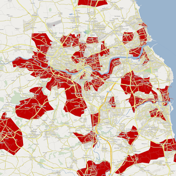
1. Franchise and territory mapping
For franchisors, defining territories is one of the biggest strategic decisions you will ever make. Get it wrong and you risk unhappy franchisees, coverage gaps or overlapping territories that cause conflict.
Geomarketing allows you to:
- Build territories using meaningful measures, such as population, households, income bands, business counts or a mix of indicators.
- Use drive time analysis to ensure territories are practical for franchisees to service.
- Create a full national or regional territory network that supports long term expansion, not just the next couple of deals.
At Atlas Mapping, this is a core part of what we do. Our Vision software and consulting services help you design franchise territory networks that balance opportunity with fairness, then share those territories clearly with franchisees and investors.
2. Branch and store network planning
If you operate branches, clinics, merchants or showrooms, geomarketing answers questions such as:
- Where are the gaps in our current network
- Which sites are cannibalising each other
- What would happen if we closed, relocated or opened in a specific area
By mapping your existing locations against customer demand, demographics and competitors, you can test scenarios before committing capital. This is far more reliable than relying on a single “good site” that happens to be available on the high street.
Atlas Mapping supports this through services such as branch planning and store market planning, built around your data and delivered through Vision so you can keep testing scenarios over time.
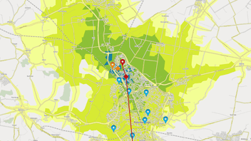
3. Field team and service area optimisation
For brands with mobile teams, such as healthcare, home services or B2B sales, geomarketing helps design sensible service areas and call plans.
Using location data, you can:
- Reduce travel time and fuel costs by creating efficient territories.
- Balance workload between team members.
- Highlight clusters of high value customers who need more frequent visits.
Vision makes this easier by giving your teams a clear, visual view of their patches, rather than asking them to interpret complex spreadsheets or static maps.
4. Location based marketing and local SEO
While Atlas Mapping focuses primarily on strategy and territory design, the same geomarketing principles extend into your day to day marketing activity.
Location based targeting helps you:
- Run local campaigns in postcodes or towns that match your ideal customer profile.
- Focus PPC and social ads on catchments around your branches or franchise territories.
- Support local SEO by understanding which areas you really want to rank for, rather than chasing visibility everywhere.
Once you have clear territories and priority areas from Vision, your marketing team or agency can use that insight to build sharper, more efficient campaigns.
What goes into a geomarketing project
Geomarketing can sound technical, but the core ingredients are straightforward.
1. Your internal data
Customer postcodes, sales by location, enquiries, current territories, site lists, franchisee locations and field team bases are all rich inputs.
2. External datasets
Demographics, household counts, business counts, drive times, deprivation indices and other third party data help you understand the population and business landscape around you.
3. Mapping and analytics tools
Traditional GIS tools can be powerful but often feel clunky for commercial teams. Atlas Mapping’s Vision platform is designed to keep the power while removing the complexity, so decision makers can actually use the insight instead of waiting on specialists.
4. Clear commercial questions
Geomarketing works best when tied to real decisions, for example “we want to grow from 50 to 100 territories in the next five years” or “we need to rationalise our branch network without losing coverage.”
When these pieces come together, you get a robust location strategy, not just a set of attractive maps.
How Atlas Mapping brings geomarketing to life
Atlas Mapping is built around a simple idea. Use geography and data to solve complex business problems with logic and grace.
Here is how we typically help clients put geomarketing into action.
Vision software
Vision is our online mapping and territory management platform. It gives you:
- Interactive maps with your own data and our trusted data sources combined.
- Territory mapping tools to design, adjust and share franchise or field territories.
- Scenario planning, so you can test growth plans before committing.
- Easy sharing with stakeholders so everyone sees the same picture.
Specialist services
Alongside Vision, our team can support you with:
- Territory Mapping for new or established franchisors.
- Branch Planning and Store Market Planning for multi site brands.
- Field Team Planning to create efficient, balanced service areas.
- Mapping as a Service if you want ongoing expert support rather than building in house capability.
We work across franchising, private equity, healthcare, trade merchants and mobile service brands, taking what works in one sector and tailoring it carefully to another.
Getting started with geomarketing
If you are new to geomarketing, you do not need to overhaul everything at once. A simple, practical starting point might look like this:
- Define the decision you care about most
For example, “where should we open the next five locations” or “how do we design a national territory network.” - Gather the basics
Pull together your customer and location data, even if it is not perfect yet. Postcodes, sales figures and existing territories are more than enough to start. - Map your current reality
Seeing your current network and demand on a map is often an aha moment. Gaps, overlaps and unexpected hot spots become obvious. - Explore scenarios
Work through different options, such as alternative territory structures or branch locations, and see the impact before you commit. - Turn insight into action
Use your new location intelligence to brief franchise sales, property teams, board members and marketing partners.
If you would like support with any of this, Atlas Mapping is here to help. As your location strategy partner, we combine geomarketing, mapping software and real world experience to give you a clear, confident plan for where to go next.